St James, Temple Sowerby: Sea Level
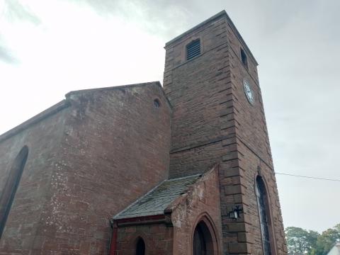
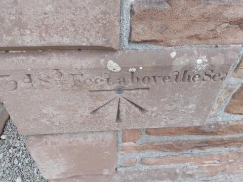
On the Parish Church of St James, at Temple Sowerby, Westmorland, is a rather peculiar detail inscribed onto the sandstone out of which it is constructed. For reasons best known to themselves*, the builders or church wardens back in 1770 informed the visitor that he was 348 ¾ feet above sea level. Whether this was to allay early anxieties about rising sea levels or a nice little fact to ponder as one anticipated a dull sermon, I cannot tell.
Twice in the book of Revelation is something thrown into the sea:
Then the second angel sounded: And something like a great mountain burning with fire was thrown into the sea, and a third of the sea became blood. (8:8)
Then a mighty angel took up a stone like a great millstone and threw it into the sea, saying, “Thus with violence the great city Babylon shall be thrown down, and shall not be found anymore…" (18:21).
The Lord Jesus Himself, in the 21st of Matthew, talks of a mountain being thrown into the sea. In Daniel 7:3, the four great pagan empires emerge from the seas:
And four great beasts came up from the sea, each different from the other...
While again in Revelation 13:1, John beholds a monster emerging from the oceans:
Then I stood on the sand of the sea. And I saw a beast rising up out of the sea, having seven heads and ten horns, and on his horns ten crowns, and on his heads a blasphemous name.
I suspect that in many of these references, if not all of them, the sea is a metaphor for the godless nations. We the church must be well above sea level, not debasing our theology to accommodate the waves, and being careful not to be swept away by its dangerous squalls. The higher above sea level we are, the more we stand out, but the safer we shall ultimately be. Persecution seldom destroys the church, but assimilating the world always does.
*A better informed reader has contacted me and shared this:
The mark on the wall of the church at Temple Sowerby is a 'benchmark', one of thousands across the land put on substantial buildings by the Ordnance Survey (there's one on Clitheroe library). The TS one is unusual for having its elevation carved into the building; elevation is normally only on maps. The horizontal line above the arrow is intended to be deep enough to take one end of a bench from which to take further readings.
- Log in to post comments
 Sunday Worship 10.45am & 6.00pm